Seattle Washington Quake

From the USGS National Earthquake Information Center:

Mw6.8 Earthquake in WASHINGTON 28 February 2001 The Nisqually Earthquake

Date & Time: February 28, 2001 10:55am PST
Magnitude: 6.8
Location: 20km NE of Olympia, Washington, 47.2 N 122.7 W
Depth: 52 km

The location of this earthquake is very near the location of the 1949 magnitude 7.1 earthquake.The February 28, 2001 event occurred on a normal fault within the down-going Juan de Fuca plate. The earthquake name "Nisqually" is derived from a prominent delta in South Puget Sound. The area northeast of the delta (along Puget Sound) is known as Nisqually Landing. The delta is protected as part of the Nisqually National Wildlife Refuge. The original name derives from local Native Americans.

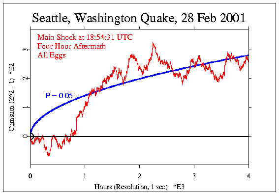
For a charming perspective on the quake, you may be interested in the Earthquake As Artist webpage, where the oscillations of a "Sand Pendulum" drew unusual designs apparently reflecting the movement of the earth itself.

The GCP data showed a marginally significant deviation (p = 0.06) for the four-hour aftermath we use to look at such events.

Seattle Washington
Quake, Half-Hour surrounding

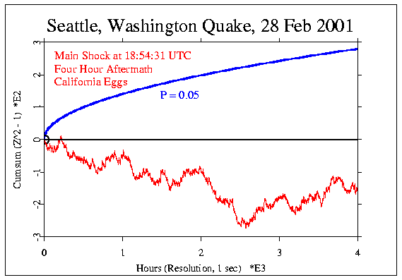
Curiously, but instructively in the context of our ongoing question about the non-locality of effects on the EGG network, the three eggs closest to the earthquake site, all in California, did not show a trend like the network as a whole, and indeed had a downward trend that reduced the overall network deviation. This trend isn't siginificant, but is quite distinctive.

Seattle Washington
Quake, three California Eggs Only


GCP Home